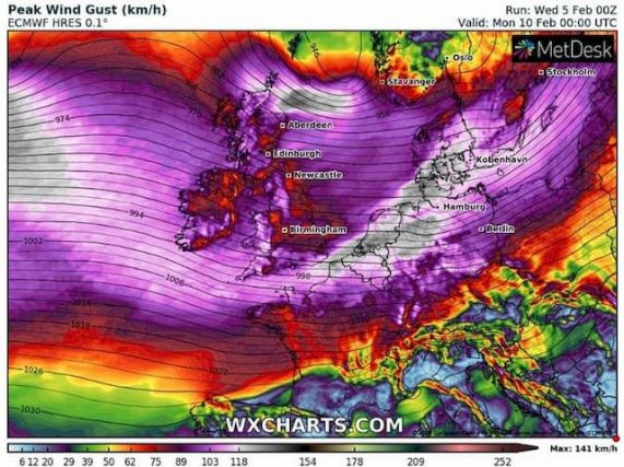
Weather: Storm Ciara will Strike from Sunday to Monday, before a Very Rough Week

She is powerful. It is formidable. Its area of influence is immense. It is rampant in the North Atlantic and will launch its forces – gusts and waves – to attack Scotland, Ireland, England and France, from Sunday to Monday. Baptized Ciara by the British – a Celtic name -, this storm will be helped in its assaults by a weighty ally: a monstrous jet-stream that blows at 400 km/h. Strong agitation will reign over our regions all next week.
We no longer know where to turn. The coming days will make us dizzy, literally and figuratively. At sea level, a gigantic vortex – a violent depression – will swirl over a large part of the North Atlantic. Look up now: up there, up there, at an altitude of 10,000 meters, the jet stream will cross the ocean from North America to sweep across Western Europe 400 km away / h. And this is not good news at all. Because the figure is extreme.
Since we are at the top of the troposphere, let’s stay there. It is here, at an altitude of 10 km, that airliners fly. And, from Sunday, this jet stream will significantly change the flight times between North America and Europe, depending on whether the planes go east or west.
#StormCiara will bring wet and windy weather across the UK this weekend. Find out the details with Alex Deakin 📺👇🏾
Stay #WeatherAware ⚠️ https://t.co/Lc8QPAjKNm pic.twitter.com/jhwqjuXFC4
— Met Office (@metoffice) February 5, 2020
Look at the map below. It shows the state of our upper atmosphere at 10,000 m above sea level. The jet is straight, powerful, very powerful. Up to 400 km/h, we said it. Because it flows between the very low pressures in the vicinity of the Icelandic depressions and the very high pressures of the Azores high.

A strong zonal jet stream will be powering across the Atlantic by the end of the week, cranking up to 220 knots, and likely delivering some very unsettled and stormy weather to NW Europe. pic.twitter.com/ksJ5shiTN8
— wxcharts – a MetDesk Company (@wxcharts) February 5, 2020
Ciara, Celtic first name, damn character
All this fury at altitude will greatly influence the phenomena placed below. Like depressions, for example. Like the one that will concern us from Sunday to Monday, at sea level and on the cows floor.
It already has a name. Baptized by the British (who are not the same letters of the alphabet as us), it is called Ciara. Celtic first name. And damn character. Look at the map at the top of the article : this is it.
Dimanche, avec la mise en place d’un puissant flux d’ouest, des vents violents sont envisagés sur le nord du pays. La probabilité de rafales > 100 km/h entre Manche, Angleterre et frontières du nord est élevée selon le modèle d’ensemble WRF 8 km. pic.twitter.com/CoP0A2ypia
— Keraunos (@KeraunosObs) February 5, 2020
It is huge (over 4,000 km in diameter), it is hollow, it is powerful. And luckily for us, she likes high latitudes. Scotland, Ireland, England, will suffer its full wrath, with winds up to 150 km/h.
We in France will also know the effects – a little less. From Sunday mid-day, the wind will start to rise along our Atlantic coast. Oriented to the southwest, it will strengthen throughout the day and swing gusts from 80 to 90 km / h, up to 110 km / h on the exposed peaks – even 120 km/h on the coast of Opal and more on exposed caps.
Overall, the departments of Finistère, Morbihan, Manche, Seine-Maritime, Nord and Pas-de-Calais should be the most affected by the wind on Sunday, all of Hauts de France and Grand Est being rather concerned Monday.
And it will last at least until Monday in the middle of the day, as shown in the map below

Strong tidal coefficients
The winds will then turn to the west, then to the northwest. Strong, always. Dangerous, again. The more so as they will rage while the high tides of February are there.
And that too is not good news at all. The tidal coefficients will be 98 Sunday evening, 103 Monday morning and 106 Monday evening. Suffice to say that the swell formed (up to 8 meters along the Brittany coast) which will surge in the full of water may cause damage and that the risk of wave-submersion will be real.
Very violent gusts to Belgium and the Netherlands
And this will be just as true for the North Sea, Belgium and the Netherlands. Look at the map below: the most violent gusts will hit these two “flat countries”. And the risk of submersion will, therefore, be very real.
In addition, the north of Germany and Denmark should also be affected by the slaps of Ciara

Lots of rain and a hectic week
So much for saltwater. For freshwater, needless to say, that the rains will be torrential over much of Western Europe. With us, the bad weather will be particularly marked from Sunday morning until Tuesday at the start of the day.
At the end of the day Monday, Western Europe will start to experience a bit of a break, at least for the wind. For a short time. The jet stream remaining very active until the end of the week, it could displace or even amplify the disturbances placed below. This will no doubt be the case on Thursday and Friday.
As the map below shows, on Thursday morning, Ireland and the North West of France are expected to experience another episode of strong wind again.

Before the arrival of new winter depressions, in the days that follow. Hopefully, they will take a more classic
turn.
Enjoyed this? Get the week’s top France stories
One email every Sunday. Unsubscribe anytime.


