Weather. Icy Cold Weather will Arrive Over France this Weekend

WEATHER: A shift of temperatures for France by the weekend as icy cold weather descends across the country …
While 2018 is already among the three warmest years since 1900, and that the month of October has been remarkable, so far, by its mildness, even its summer temperatures, winter will launch a brutal offensive this week and until at least Tuesday. No region will be spared. In addition to the north-north-east wind and the rain, or even the snow at low altitude, the cold will drop the thermometers to December values.
Forget about the Indian summer and the sometimes summery sweetness that prevailed so far this October: here comes the cold, the true, the winter temperatures (at least for a month of October) – and, incidentally, the wind and rain, even snow in plain. We will almost go from summer to winter without going through the autumn box.
In question: a descent of polar air on our country. In other words, a mass of polar sea air, currently located near the Arctic, not far from Spitsbergen, will debouch Friday on the north of France. Before moving south on Saturday and settle for several days, until Tuesday at least
Coup de #froid ce week-end / invasion d’une masse d’air polaire maritime sur la France : l’air qui sera dimanche 28/10 au soir sur le #PaysBasque est actuellement situé dans l’#Arctique, pas loin du Svalbard.
rétro-trajectoire NOAA HYSPLIT basée sur le run GFS de ce 23/10 12UTC pic.twitter.com/3XF45Ufr77
— Etienne Kapikian (@EKMeteo) 23 October 2018
Prévision || Première offensive hivernale : le mois d’octobre a été remarquablement doux jusqu’ici, mais les températures chuteront ce week-end. https://t.co/GNgHsRYiX1 pic.twitter.com/HWMlu5oW3o
— Météo-France (@meteofrance) 23 October 2018
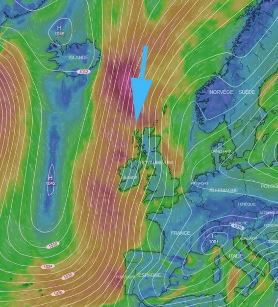
Translate: the wind will blow from the north and plummet all schuss at home from the high icy latitudes. Yet the anticyclone is there. Often synonymous with good weather, this phenomenon of high pressures will unfortunately be positioned fairly north and extend by a long dorsal.
Look at the map below: the wind, which turns clockwise around an anticyclone in the northern hemisphere, rises to the far north, catches chilly air and descends to the south to deliver this cold all fresh

As the announcement Meteo France, “from Friday, a cold air mass of maritime polar origin will flow through the Channel, to win the whole country in the day of Saturday. Temperatures will drop dramatically, with rain and even snow at low altitudes on all Sunday massifs. “
#Neige : elle va faire son retour dès samedi et tombera de plus en plus bas dimanche et lundi. Plus de 30 cm en altitude et probablement de la neige au sol jusqu’à 700 m sur l’ensemble des reliefs. Giboulées possibles jusqu’en plaine lundi dans le Nord-Est https://t.co/LurtDG8MeE pic.twitter.com/eabPY2F474
— Agate Météo (@AgateMeteo) 23 October 2018
Do not panic, though: this cold and wet episode at a time should not last. Temperatures are expected to rise somewhat at the end of next week. And consolidate the high averages of the temperatures of this funny autumn.
Enjoyed this? Get the week’s top France stories
One email every Sunday. Unsubscribe anytime.


