Weather: Gale, Thunderstorms and Rain: Stormy Weekend, Rough Week

Mild temperatures, very mild. But a weather not always soft, with strong winds, heavy rains and storms sometimes violent. Here is summarised the time that awaits you this weekend and next week. The windy and wet disturbances will be linked with the regularity of a metronome.
As announced here early this week , this weekend will kick off a weather disturbed, restless, windy, wet, sometimes stormy. Spring is not for tomorrow, so? No. Except if you look at the thermometer which, in the space of less than 15 days, jumped 25 ° C on average, from -10 ° C under the onslaught of the Cold spell that came from Moscow to 15 ° C thanks to the flow of southwest from the Canaries. Clearly, we move from a beautiful blue sky with freezing temperatures to mild temperatures under a gray and rainy sky.
The wind…
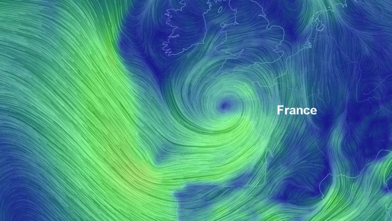
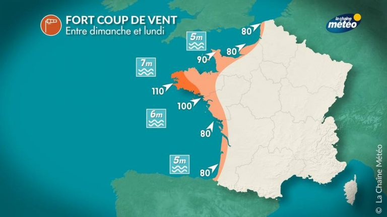
Numerical models confirm the arrival of a strong gust of wind on the North-West of France, and in particular on the Brittany region between Sunday afternoon and Monday morning.

And the forecasters of the American NOAA (National Oceanic and Atmospheric Administration) confirm this phenomenon, which could even receive the name of Félix if it is remarkable by its intensity.

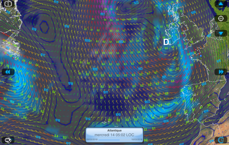
Look at the map below. In addition to the very hollow depression that touches Brittany, admire the collection of disturbances (circled black) more or less hollow (scab = gale, storm = storm, DVLPG = developing) circulating in Europe around this minimum to 968 hPa and those that cross or will cross the Atlantic in the coming days: we understand why the coming week will be windy and wet

The wind and rain forecast for Sunday:
Anyway, we are already expecting gusts generally oriented southwest at least 80 km / h in the land, 90 km / h on the Cotentin, 100 to 110 km / h on the coasts of Brittany and those of the Pays de la Loire, and around 70 km / h from Poitou-Charentes to the Hauts-de-France region.
Grande douceur en amont de la dépression atlantique #Felix en fin de semaine (localement plus de 20°C par effet de foehn) mais grande agitation et pluies fréquentes, parfois orageuses (100 mm et plus sur les Cévennes) – Animation : @metoffice pic.twitter.com/aYi9nvHYKw
— Météo Villes (@Meteovilles) 8 March 2018
Rain…
The depression that hit our country this Friday will still generate wind and rain Saturday in the northern half of France. The weather will often be gray. At the end of the day, the rains will intensify with the passage of a rain band, locally stormy.
Sunday, with the arrival of the new very hollow disturbance, the rains will resume the intensity
Mildness…
As for the temperatures, it is soft, much milder. It’s even hot!
Thanks to the southwest wind, this will be particularly the case on Saturday: in the afternoon, the maximum will often be between 12 and 16 ° C in the north, 17 and 23 ° C in the south.

After the sustained rains on Saturday night, temperatures will drop on Sunday with a softness easing but they will remain above seasonal norms with 14 to 18 ° C from north to south.
Thunderstorms…
Thunderstorms, too. The models also announce the arrival of a stormy degradation during this weekend – quite early in the season, so – especially Saturday afternoon and evening on an axis extending from the Pyrenees. to Normandy. These thunderstorms may be locally accompanied by hail and violent gusts of wind.
For this Sunday, the risk of thunderstorms will affect the East of the country, but also the Mediterranean basin.
… and a hectic week to follow
From Monday to Thursday at least, the weather will remain very disturbed. The disturbances will succeed one another, especially in the Northwest, with a generally strong wind and sustained rains.
The wind and rain forecast for Wednesday morning:

Most depressions will take roughly the same path. Coming from quite low in latitude, they will progress gradually towards our country via the near-Atlantic, Cape Finisterre and the Bay of Biscay before touching the West.
The temperatures will remain mild, even above the normal of season. But waxed, raincoats and umbrellas will barely have time to dry from one day to the next.
A little poetry…
To console us for all this gray roughness, finish with a poetic and colourful image from Lapland. It’s true, the temperatures are low, up there – icy, even. But the sight of the snow falling as an aurora borealis waving its green drapes does not make it shiver cold.

storms
Enjoyed this? Get the week’s top France stories
One email every Sunday. Unsubscribe anytime.


