Weather: Nine Departments Placed on Orange Alert for Snow and Ice

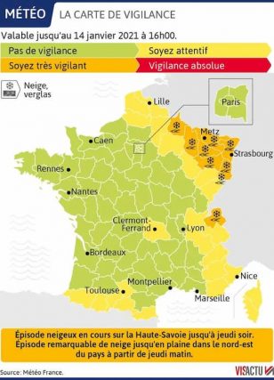
WEATHER ALERT: Nine departments in eastern France were placed on orange alert for snow and ice this Wednesday 13th January, Meteo France announced
Nine departments in eastern France are now on orange alert for snow and ice, Meteo France indicates this Wednesday 13th January in a national alert bulletin.
Seven of them are located in the Grand Est region : the Ardennes, the Meuse, the Moselle, the Meurthe-et-Moselle, the Vosges, the Haut-Rhin and the Bas-Rhin. While the territory of Belfort in Bourgogne Franche-Comté is also concerned by the alert.
For these regions, Météo France qualifies the meteorological situation as “a remarkable snowfall”

“In these departments, we expect accumulations of the order of 7 to 15 centimetres over the episode, or even locally a little more. Around Strasbourg and northern Alsace, the amounts of snow seem lower, rather around 3 to 7 centimetres. Such values have become unusual in the plains over the last few winters, ” notes Météo France.
No overtaking on the roads
Up to 30 centimeters of snow can fall on the Vosges mountains, said the Haut-Rhin prefecture.
This has put in place a ban on overtaking on all roads and highways in the department for vehicles over 7.5 tonnes, which may not travel at more than 80 km/h.
In the Meuse, Moselle and Meurthe-et-Moselle, school buses will not run on Thursday.
The Haute-Savoie department also affected
The department of Haute-Savoie, in Auvergne Rhône-Alpes, is also affected. Météo France specifies that this winter episode is not “exceptional for the regions concerned but sufficiently significant to make traffic conditions difficult”.
We expect 10 to 20 centimetres of snow, locally 30 centimetres in this department.
On Twitter, the account of the Ministry of the Interior invites people residing in these regions to “Limit (r) [their] movements and facilitate (r) the passage of snow-clearing machines “. Adding: “stay cautious and stay informed”
A new disruption scheduled for late afternoon in the Alps
For the Alps region, Météo France indicates: “We have enjoyed a nice lull since this morning. In the middle of the afternoon, it begins to flake from an altitude of 500 or 600 m in the interior valleys of the Alps. On the outskirts of the Jura and the pre-Alps, the snow limit is rather around 800 or 900 m. ” Météo France announced a new disturbance in “ late afternoon ” on January 13th. This disturbance will “continue in the north of the Alps until the end of the day on Thursday” with “moderate precipitation, sometimes heavy” , especially in Haute-Savoie.
Snowfall will intensify in the Northeast on January 14th
While in the North-East, Meteo France reports mainly rain for the moment. However, “some snowflakes are possible in eastern Lorraine and the Vosges. Some roads can remain slippery from the middle mountains because of the still cold pavements linked to the severe frosts of recent days, ” warns Metée France.
For this area, the situation should change during the night of January 13th to 14th. “The snowfall will make a comeback and intensify in the morning on the departments in orange vigilance. They continue until Friday the 15th in the morning ”, it is specified.
The north, the Aisne, the north of the Haute-Saône and the Doubs, are placed in yellow alert
Snow has already fallen in abundance in recent days in Rhône-Alpes, where 2,000 motorists were stranded overnight from Tuesday to Wednesday on the A40, in the Ain, after an accident .
Enjoyed this? Get the week’s top France stories
One email every Sunday. Unsubscribe anytime.


