Violent thunderstorms this Thursday in France: the Var Remains on Orange Alert, dozens of Departments in Yellow

Sometimes violent storms accompanied by hail and strong gusts of wind are still to be feared in France this Thursday 28th August 2025. The latest forecasts.
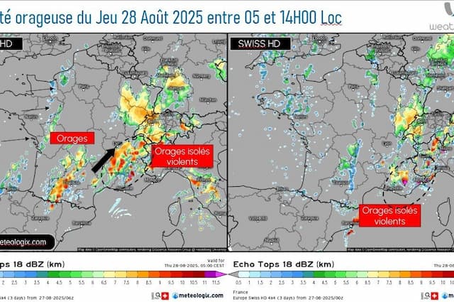
THE thunderstorms are violent, it’s not over. The stormy deterioration that began on Tuesday now extends to the Mediterranean regions – linked to storm Augustine from now on – and will persist this Thursday 28th August 2025 on the eastern flank, in particular from the Alps to the Provence-Alpes-Côte d’Azur region, with, once again, significant accumulations of rain to monitor and potentially dangerous phenomena.
In its bulletin, updated at 12 midday. this Thursday 28th August 2025, Meteoo France thus maintained around fifty departments on alert. Among them, a remainder in orange alert, this is the Var, for thunderstorms and rain-flood.
Pour jeudi 28 août 2025 :
🟠 1 département en Vigilance orangeRestez prudents et informés :https://t.co/JGz4rTUvHP pic.twitter.com/tlse4Et3XW
— VigiMétéoFrance (@VigiMeteoFrance) August 28, 2025
The departments placed on alert for this Thursday, August 28, 2025
Ain: storms
Alpes-de-Haute-Provence: rain-flood, thunderstorms
Hautes-Alpes: rain-flood, thunderstorms
Alpes-Maritimes: rain-flood, storms
Ardèche: rain-flood, storms
Ardennes: storms
Ariège: storms
Dawn: thunderstorms
Aude: storms
Aveyron: storms
Calvados: storms
Cantal: rain-flood, floods
Corrèze: storms
Thunderstorms:
Côte-d’Or: storms
Doubs: storms
Drôme: rain-flood, thunderstorms
Eure: storms
Gard: storms, floods
Haute-Garonne: storms
Gers: thunderstorms
Hérault: storms, floods
Ille-et-Vilaine: storms
Isère: rain-flood, thunderstorms
Jura: storms
Loire: rain-flood, storms
Haute-Loire: rain-flood, storms, floods
Lot: thunderstorms
Lot-et-Garonne: storms
Lozère: storms, floods
Channel: storms
Marne: storms
Haute-Marne: storms
Mayenne: storms
Meurthe-et-Moselle: storms
Meuse: storms
Moselle: storms
Nièvre: storms
Orne: thunderstorms
Puy-de-Dôme: rain-flood, floods
Hautes-Pyrénées: storms
Pyrénées-Orientales: storms
Bas-Rhin: storms
Haut-Rhin: storms
Rhône: rain-flood, storms
Haute-Saône: storms
Saône-et-Loire: storms
Savoie: rain-flood, storms
Haute-Savoie: rain-flood, thunderstorms
Seine-Maritime: storms
Tarn: storms
Tarn-et-Garonne: storms
Vaucluse: rain-flood, thunderstorms
Vosges: storms
Yonne: storms
Terr. de Belfort: storms
Andorra: storms
This Wednesday, a new rainy disturbance caused a very active storm degradation from the Pyrenees to the eastern borders, with hail and strong gusts of wind.
And this night from Wednesday to Thursday August 28 remained very turbulent over the southern half of the country with temporarily intense stormy rains, particularly from Occitanie and Auvergne-Rhône-Alpes to Jura and the south of the Grand Est, then as far as Provence-Alpes-Côte d’Azur.
We were expecting cumulative rainfall of around 80 to 100 millimeters in a short time on the coastal domain in an area going from Marseille to the Côte d’Azur, accumulations of around 40 to 60 mm in a short time in an area going from the east of Bouches-du-Rhône east of the Var, wind gusts of around 80 to 100 km/h and hail.
The storm line currently in progress is gradually shifting to the east of the Var, mainly affecting the coast even if a few storms are still possible in the interior. These storms are associated with accumulations of rain locally of around 50 to 80 mm in a short time, particularly on the coast. Over the episode, accumulations can be around 80 to 100 mm locally, wind gusts of around 80 to 100 km/h and hail.
Meteo France at midday this Thursday

The arrival of an ancient tropical storm, named Fernand, this weekend
From Aquitaine to the English Channel and north of the Seine, the sky will be more changeable, divided between clearings, cloudy periods and sometimes showers. The west to southwest wind will also become noticeable in western regions: it will sometimes blow in gusts of up to 50/60 km/h in showers. And, in the southeast, it is the tramontane which will strengthen to reach around 70 km/h in gusts afternoon.
And what about temperatures?
And on the afternoon of this Thursday 28th August, the drop in temperatures will continue: it will be 19 to 21°C near the Channel, 21 to 24°C in general. Temperatures will remain warmer from eastern Languedoc to the Provence-Alpes-Côte d’Azur region with 26 to 30°C and especially in Corsica where 30 to 34°C are still forecast.
The rest of the weather menu? After these violent storms, the temperatures will continue to drop and these are the remains of’an ancient tropical storm, named Fernand, which promise still choppy weather at the end of the week, notably Friday 29th August and Saturday 30 August 2025.
Enjoyed this? Get the week’s top France stories
One email every Sunday. Unsubscribe anytime.


