Weather: The Vendée Placed on Orange Alert for Strong Winds

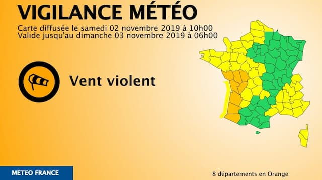
The prefect of the Vendée has triggered the state of orange alert for the weather across the region for high winds.
The Vendée prefect , in view of the information provided by Météo – France, has triggered the orange – level meteorological warning for high winds.
The department is also placed on yellow alert for rain-floods and thunderstorms.
The first storm of the winter season requires special vigilance.
The alert is triggered from Saturday 2nd November at 10pm .
“The depression related to the storm “Amelie” is located this morning at 6 am at a little less than 1 000 km from Ireland (around 990 hPa), gradually widening.”
Showers circulate in a southwesterly flow over our regions.
In the course of the next night, the depression will circulate on the south of Brittany. The associated winds will become stormy.
The coast and the south Vendée
The southern part of the department of Vendée and the coastal fringe will be particularly exposed.
The wind, from the south-west at first, will gust 100 to 110 km/h in these areas, punctually a little more on the coast. They will be associated with heavy rainstorms.
The wind will turn to the northwest at the end of the night, with gusts of 90 to 110 km/h or even 120 km/h on the coasts and islands. Associated with this storm, the state of the sea will become dangerous, with strong breakouts at the coast.
“All the mayors of the department were alerted of this situation to implement the measures of communal safeguard plans intended to inform the population and alert their technical services. “
The possible consequences
Power and telephone outages can affect distribution networks for relatively long periods of time.
Roofs and chimneys may be damaged.
Tree branches may break. The vehicles can be deported.
Road traffic can be disrupted, especially on the secondary network in forest areas.
Some damage can affect electricity and telephone distribution networks.

Enjoyed this? Get the week’s top France stories
One email every Sunday. Unsubscribe anytime.


