Weather in the Northwest: Gales on Sunday with Full High Tides

And here comes the first autumnal depression of the season. Not very bad, all right, but … that will sway Sunday bursts of 40 to 50 knots in full tide of equinox, with coefficients of 113 and 115. Wind, so. But also waves and obvious risks of submersion. Caution!
Let’s go. The season of Autumn is well and truly launched with the arrival of a first dog. Not very biting, it’s true – it will not be a storm – but it will still scold trees and roofs.
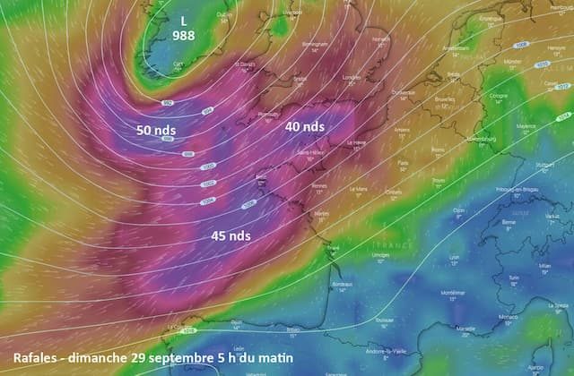
Look at the map at the head of the article : Sunday morning, an Atlantic depression all that is classic tackles the Irish coast from the ocean.
Relatively low (988 hPa for the American model GFS presented here, 989 hPa for the European Center for Medium-Term Forecast), it will generate south-southwesterly winds over Finistère, Morbihan, Loire-Atlantique, which will be in the first line of the wind … and waves.
Because, it should be noted, this gust of 35 to 45 knots will occur in the middle of the great tides of equinox: the coefficients will indeed be 113 and 115 Sunday (103-108 Saturday and 116-115 Monday). Suffice to say that the risk of wave-submersion will be very high throughout Brittany South and to the Pays de la Loire. Maximum caution, therefore!
This warning is just as valid for the coasts of North Brittany and the Cotentin, which will undergo – differently certainly, but still markedly – the assaults of the wind and the tide.

Look at the map above : it shows the values of the gusts expected Sunday morning. From 40 to 50 knots (from 70 to 90 km / h), it’s starting to get windy.
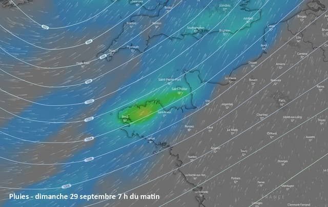
Side precipitation, after a very good Saturday on the northwest, Sunday will be windy, but also gray and rainy. As shown in the map below , still for Sunday morning, the rain will cross our regions from East to West. Slowly. The day will be very wet until the end of the day, from Ille-et-Vilaine to the Ile-de-France.

It has been said: it’s the launch of the fall season. Tuesday, another Atlantic depression could pour over the west of France. But, again, nothing too bad. Nothing, next to what might appear next weekend, with the arrival of Hurricane Lorenzo.
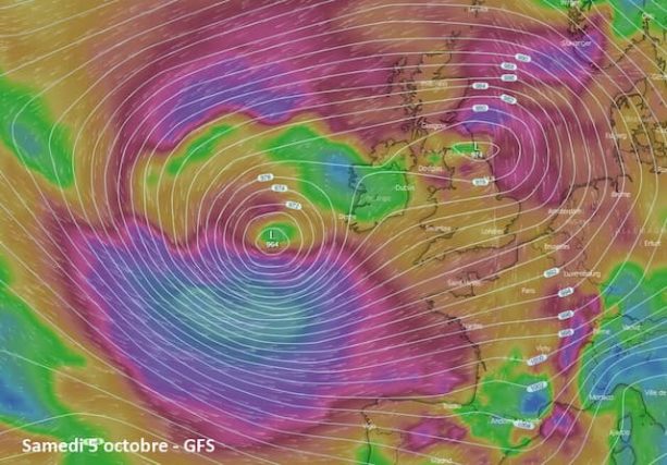
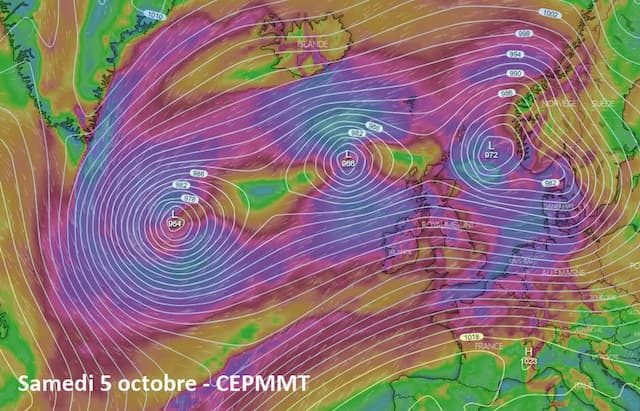
Born near the coast of Africa, it should rise quickly north instead of going to the West Indies, go around the Azores anticyclone and finish its race … not far from our shores. Feeding other Atlantic depressions – and being powered by them.


Look at the two maps above : yes, it’s impressive. One is signed by the American model GFS, the other from the European model ECMWF. We do not know which one to wish. And we will obviously review the point early next week.
#HurricaneLorenzo is due to track a little further NW’ward this weekend, moving over some very warm waters.
These high sea surface temperatures (27-28C) could potentially fuel #Lorenzo with enough energy to become a cat 5, before veering NE’ward over cooler waters next week. pic.twitter.com/Dp7zNoyb8V
— wxcharts – a MetDesk Company (@wxcharts) 27 September 2019
Enjoyed this? Get the week’s top France stories
One email every Sunday. Unsubscribe anytime.


