Weather: Cold, Snow and Wind, Winter Launches Offensive Next Week

WINTER WEATHER: From the middle of the week, cold, wind, snow flakes and ice will come back in force across France as the winter weather arrives. Prepare yourselves.
At the end of almost three weeks of an anticyclone lazily laid on our country, and while the winter has autumn remorse, oscillating constantly between the soft and the gray, here is the wind, the cold and the snow which point the tip of their nose. Just to remind you that we are in the heart of the coldest months of the year and that white is still in season. From the middle of the week, wind, snow flakes and ice will come back in force. Prepare yourselves.
Moscow-Paris, do you remember? It was in February 2018, a little over a year ago, so. A current from east-north-east, straight from Russia, had engulfed our territory , bringing very cold, but also a rather dry weather.
What awaits us next week, from Tuesday and Wednesday, is somewhat different. It’s true, the weather period is not very different: end of January, vs end of February. That’s right, the air masses will also come from the east-northeast. But the phenomenon will be less important, its intensity too, snow and rain will be more present and the drop in temperatures will be a little less marked.
Comparison between Moscow-Paris from February 2018 and the situation planned for the end of next week:
Cold for the foreseeable but how does the latest forecast compare with #BeastFromTheEast last year?
Similar idea but the intensity of cold isn’t quite there. Also, the setup is delicate for Ireland and UK this time. The coldest weather could remain over the continent… pic.twitter.com/jgbUcZJOV0
— Scott From Scotland (@ScottDuncanWX) 18 January 2019
This does not stop our British friends from poetically speaking, like last year, of “Beast from the East” – translate: “the Beast coming from the East” (tweet below) . If the term may seem exaggerated, it will still be expected to wind quite strong, freezing temperatures and snowflakes on the landforms, but also possibly to the plain. In other words: real winter weather.
Models have come to an agreement. #BeastFromTheEast is looking likely.
Compare these models in one panel here with probability charts –> https://t.co/LHcbMCnQwl pic.twitter.com/537PlPAfDJ
— wxcharts (@wxcharts) 18 January 2019
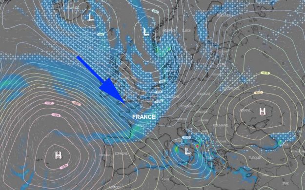
It will all start on Tuesday, with the conjunction of a triple phenomenon (map below) : an anticyclone on the near Atlantic easing gently and sliding westward, leaving the passage to a glacial north-west flow propelled by two depressions very north, and the presence of a third depression in the south, centred on Italy.

> The animation of the forecasts of the European model for the end of next week:
The northwesterly flow will bring rain Tuesday morning on the west, which may be preceded by a few flakes. These will be more numerous in the Pyrenees, the Center and the East of the country; the latter two regions will also be subject to numerous freezing fogs. Caution will be put on the roads and this advice will remain valid for the next four days.
> The animation of the forecasts of the European model for the end of next week:
WATCH the chatter of the European weather world summed up in 4 seconds.
Impressive run with #BeastFromTheEast scenario. The signal for significant cold is strengthening day by day with ECMWF on the same wavelength.
Maps: @wxcharts pic.twitter.com/u7Hzliash9
— Scott From Scotland (@ScottDuncanWX) 17 January 2019
Indeed, from Wednesday, temperatures will drop significantly, and snowfall should intensify over a good half of eastern France. That said, Normandy should not be spared, as well as the Pays de la Loire and the Paris region – difficult traffic in sight, therefore, particularly in Ile-de-France.
Thursday, these flakes may be interesting – with different intensities, it’s true – virtually all regions of our country, the tip of Brittany and Côte d’Azur excepted.
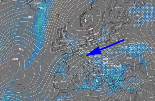
On the phenomenon side, we can observe the changeover made since Tuesday (map below) : the depression centered on the Mediterranean remains in place, favouring easterly winds over our country, themselves reinforced by the presence of an anticyclone income north of our country: here we are caught between two fires, so – except that these two generate cold!

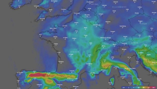
Friday, Saturday and Sunday, the “Beast of the East” will be there. Mercury thermometers, after a nice free fall (map at the beginning of the article) , will remain stubbornly stuck in the blue and the negative, even during the day, in many areas. Only the coastal strips and the South will remain relatively preserved.
The cold offensive in action next week:
L’offensive hivernale se confirme. Mardi, un décrochage arctique assez massif devrait s’opérer vers l’ouest de l’Europe et la France avec creusement dépressionnaire marqué dans le Golfe de Gênes. #Neige, vent et froid au programme. pic.twitter.com/ninAx0jMGl
— Keraunos (@KeraunosObs) 18 January 2019
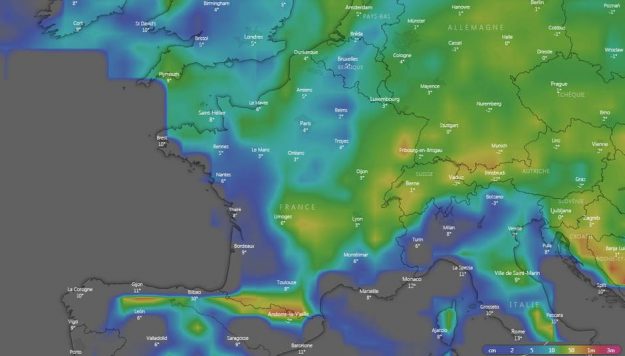
The north-north-easterly wind will bring with it severe winter conditions and snow accumulations can sometimes be important (maps below) .


As you can see, the US model (GFS) and the European model (ECMWF) do not completely agree on new snow values for the next ten days. Normal: some forecasts favor slightly drier air from the north-east (a bit like during the Moscow-Paris last year). But they agree at least on the fact that an episode of cold, snow and wind will affect us at least from Tuesday-Wednesday to Sunday.
Can we already speak of a “cold wave”? Not for the moment, but we are still heading towards several consecutive days of freezing temperatures. Recall that a cold wave is “a prolonged period of low temperatures most often negative diurnal and nocturnal over a large part of our territory.” It may or may not be accompanied by a strong wind that increases the feeling of cold.
“Winter is coming” , to quote the most famous quote from Game of Thrones. Winter decides (finally) to play its role. All the better: nothing more unpleasant than having the impression that there is no more season.
Enjoyed this? Get the week’s top France stories
One email every Sunday. Unsubscribe anytime.


