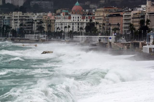
Storm Benjamin has just Been Named and it will Hit us this Thursday: What Consequences in France?

On the morning of Thursday 23rd October, we can already expect wind gusts of up to 120 km/h in the north-western part of France. We can even go up to 140 km/h in the afternoon.
While one first depression from the British Isles hit France at the start of the week, we logically looked for a long time at neighboring meteorological services to find out if we were going to face a storm and what would its name be, in agreement with the names of the storms for the 2025-2026 season.
It’s finally on the side of the Royal Meteorological Institute of Belgium (IRM) – which also works with Portugal, Spain and Luxembourg – that the information came this Wednesday, October 22, 2025: a new storm has been officially named.
Seven departments on orange alert Thursday
No Bram as stated by Météo France: in accordance with the list of Belgian weather services, this new storm is called Benjamin. It is preparing to reach France from Thursday 23rd October 2025, as weather models had anticipated.
Météo France was quick to react to this appointment. Our weather institution has placed seven departments on orange alert for Thursday :
- Charente-Maritime: wind
- Gironde: wind, waves-submersion
- Landes: wind, waves-submersion
- Manche: wind
- Pyrénées-Atlantiques: wind, waves-submersion
- Seine-Maritime: waves-submersion
- Vendée: wind
Pour jeudi 23 octobre 2025 :
🟠 7 départements en Vigilance orangeRestez prudents et informés :https://t.co/JGz4rTUvHP pic.twitter.com/t60R7SXhpx
— VigiMétéoFrance (@VigiMeteoFrance) October 22, 2025
Strong winds expected
This Benjamin storm will mainly develop during the night of Wednesday 22nd September to Thursday 23rd September 2025. Indeed, in its course along the British coasts, it will deepen – gold, in meteorology, the deeper a depression deepens, the more violent winds it creates.
“When you look at altitude, you have a deep thalweg [an outgrowth of depression, Editor’s note.], which dives on the Bay of Biscay and the west of France”, analyzes meteorologist Yann Amice
At the same time, a very powerful jet stream, a real engine of atmospheric circulation, will be located directly above France on Thursday, with wind speeds exceeding 280 km/h in its core.
Up to 140 km/h locally
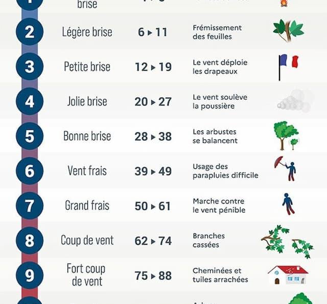
And on the ground, these gusts also promise to be significant Thursday morning: F9 on the Beaufort scale. Which corresponds, according to this table from Météo France, to a “strong gust of wind” which can “tear out chimneys and tiles” from houses.

Not of the order of 280 km/h of course, but we must now expect wind gusts of more than 120 km/h to 130 km/h facing the Atlantic, between 90 and 120 km/h on the Channel coasts, and more than 80-90 km/h inland.
In the afternoon, these winds will strengthen, with winds forecast locally up to 130 km/h on exposed headings. “In the Mediterranean, the wind will rush in the form of a tramontane, with 110 km/h. And on the Corsican reliefs, we will climb up to 120-140 km/h, adds Yann Amice.
Enjoyed this? Get the week’s top France stories
One email every Sunday. Unsubscribe anytime.


