Weather: Violent Storm and Winds Sunday and Monday in France

Ana storm arrived on Saturday evening on the Brittany and Normandy coast, bringing with it strong winds and rain in abundance for Sunday and Monday. Twelve departments were placed on orange alert snow and ice.
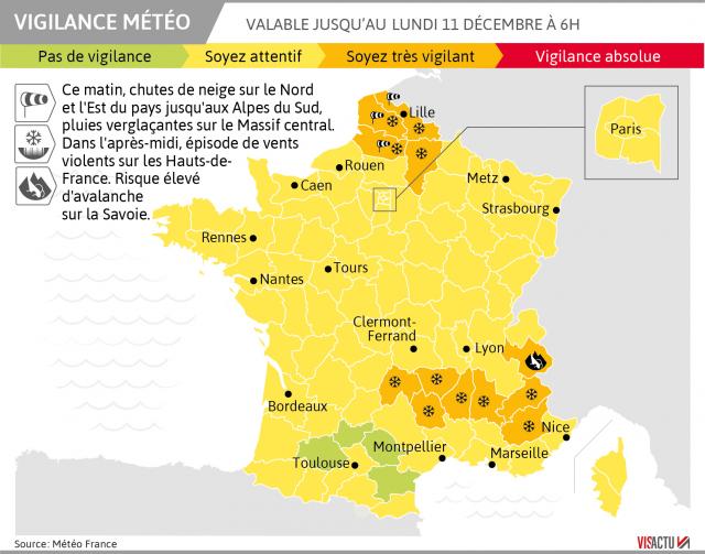
A very active disturbance will move Sunday on the Hexagon, according to forecasts from Météo-France, because of the storm named Ana. Meteo France issued a bulletin warning of high winds for Sunday and Monday. D ouze departments were placed on orange alert on Saturday late afternoon until Monday morning at the earliest, or to risk of snow and ice, or to high winds, or for possible avalanches.
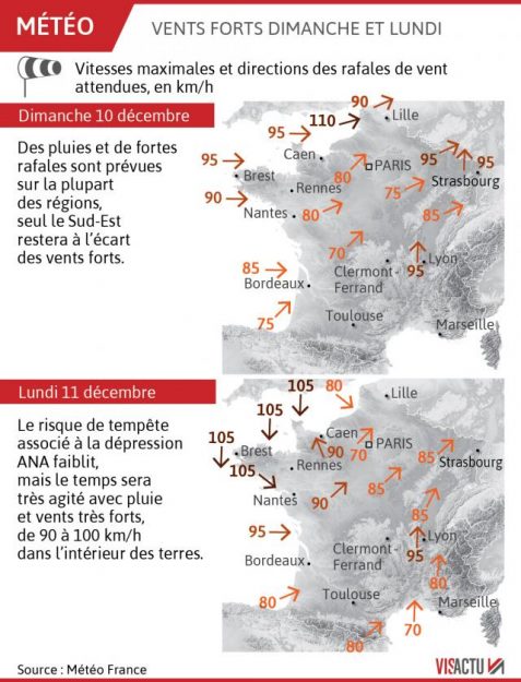
Wind gusts of 100 to 130 km/h are expected near the coast up to 100/110 km/h inland. The orange alert for snow and ice concerns the Aisne, the Alpes-de-Haute-Provence, Hautes-Alpes, Ardeche, Cantal, Drôme, Haute-Loire and Lozère, while the North, Pas-de-Calais and the Somme are affected by strong winds. Furthermore, Savoy was placed in amber alert for avalanches.

#neige/#verglas de redoux dimanche matin, suivis de pluie/averses (neige plus durable sur Alpes intérieures) + #vent violent sur Pas-de-Calais l’après-midi, puis arrivée de la #tempête #Ana dans le golfe de Gascogne (bel enroulement)
animation AROME jusqu’à lundi 06h UTC pic.twitter.com/pI2vytpEk4— Etienne Kapikian (@EKMeteo) 9 December 2017
Meteo France warned on Saturday on his Twitter account of the arrival of a weather episode“very disturbed” .
#MeteoduWE Après une accalmie samedi, le temps sera très perturbé dimanche avec #pluie, #neige, et #vent…https://t.co/oAkxOPa1eb pic.twitter.com/XkEqCeb96L
— Météo-France (@meteofrance) 8 December 2017

A time of disturbed weather from the West
“Rains and strong gusts will cover most regions, only the Southeast staying away from strong winds. Snow and freezing rain will be observed on the north and east of the country, before the rains come ” , announced for this Sunday the weather service and climatology.
Forecasts confirmed by the Weather Channel announces the tempestuous winds that sweep the coasts of the English Channel
La semaine prochaine sera très agitée avec des #pluies, des coups de vent de vent et des chutes de #neige abondantes en #montagne. Bref, du mauvais temps hivernal. https://t.co/di5KbxAKEw pic.twitter.com/R6r20xIU0b
— La Chaîne Météo (@lachainemeteo) 9 December 2017
Winds expected to reach 90 to 100 km/h partly
For Monday, “the risk associated with the storm Ana depression weakens, but we will keep a very hectic time with rain and very strong winds of 90 to 100 km/h inland. “
In Provence-Alpes-Côte d’Azur. “An episode of waves and flooding remarkable concern the Mediterranean” , reports Meteo-France.
A high risk of avalanches on the mountains
The snow should work to fall in abundance on the Alps. The risk of avalanches could be at its “maximum” level on Tuesday, warns the Weather Channel.
“The avalanche risk already high this weekend could become maximum in middle of next week on some massifs of the Alps and the Pyrenees”, they say.
Meteo France has placed the the Savoy area on avalanche alert.

Enjoyed this? Get the week’s top France stories
One email every Sunday. Unsubscribe anytime.


