Gusts at 100 km/h: New Gust of Wind in France for Several Days, Forecast for All Saints Day

A parade of disruptions are expected in France for the end of October 2025 and the All Saints Day weekend, with sometimes strong winds on the Forecast.
Back to milder weather, but also rain and wind, sometimes strong, in France. In the west and north, but also in the southeast of the country.
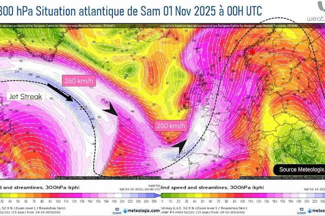
“France will find itself under the influence from a very powerful high altitude wind, a real driving force for the establishment of a southwestern, humid and windy regime, summarizes meteorologist Yann Amice.
Two windy episodes
A first depression will deepen in the coming hours, reaching a very low pressure of 960 hectopascals this Thursday 30th October 2025, in the west of Ireland. Met Éireann, the Irish weather service, could thus decide to name this depression, storm Bram, these next few hours.
“In the wake of this depression, a first episode of wind will set in in the west of France this Thursday 30th October, then a second probably even a little stronger on Saturday 1st November”, sequence Yann Amice.

Over several days, France will thus remain on the edge of this very disturbed flow on the British Isles and in the Atlantic under the influence of a deep thalweg (editor’s note: the growth of this depression off the coast of Ireland). And, at the same time, the remnants of Hurricane Melissa will return to Western Europe by the end of the weekend.
Wind gusts of 100 km/h are already modeled on the coasts of Brittany and Normandy for this Saturday 1st November.
France is preparing to experience a fairly lasting mild spell from this Wednesday 29th October. The flow will shift to the southwest, bringing up a gentle mass of air but also humid and windy under a dynamic oceanic influence between the Atlantic and the British Isles conducive to gales over the west of France and the return of ex-Hurricane Melissa in the western circulation from November 1st in the north of the Azores perimeter will maintain this gentle and humid phase over the near Atlantic.
Affected regions
After its digging phase, this low pressure system should thus remain in place in the north of Ireland and will have an influence on France with rain and wind, from this Thursday 30th October to Sunday 2nd November, at least. This active front will undoubtedly mainly concern Brittany, between Morbihan and Finistère at the end of the week.
And between now and the arrival of this very hollow depression off the coast of Ireland, the flow will move south near the Mediterranean, causing — in connection with another low pressure minimum on the Portugal — heavy rains between this Wednesday 29th October and this Thursday 30th October in the Cévennes and Provence-Alpes-Côte d’Azur as well as Corsica, fueled by a strong south wind.
And in this humid and windy atmosphere, maximum temperatures will be well above normal and could thus approach another 25 °C in the south of the country for All Saints’ Day.
Enjoyed this? Get the week’s top France stories
One email every Sunday. Unsubscribe anytime.


